Story summary


Tribal area
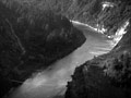
The Whanganui River marks the north, and the Manawatū River the south of Ngāti Apa’s territory. Their traditional lands lie between the Mangawhero, Whangaehu, Turakina and Rangitīkei rivers.
Ancestors
Ngāti Apa trace their ancestry to Ruatea, captain of the Kurahaupō canoe. They take their name from Ruatea’s son, Apa-hāpai-taketake (Apa), who lived near Pūtauaki (Mt Edgecumbe) in the Bay of Plenty.
Migrations
Over time, some of Apa’s descendants moved south to the Rangitīkei area. Others migrated even further south, some reaching the northern part of the South Island. Those who went to Rangitīkei intermarried with the Ngā Wairiki people, and eventually became known as Ngāti Apa.
European settlement
Ngāti Apa were initially receptive to Europeans. They signed the Treaty of Waitangi in 1840 and welcomed missionaries working in the Whanganui and Rangitīkei areas. In 1849 the tribe sold land to the government, expecting trade and other benefits. However, these benefits did not eventuate. European farming destroyed traditional food-gathering sites. Eventually Ngāti Apa lost much of their land and were reduced to poverty.
Religious movements
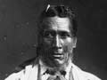
Facing so many difficulties, Ngāti Apa started several new religious movements. The prophet Mere Rikiriki inspired some important religious leaders, including Hōri Ēnoka (Mareikura), founder of the Māramatanga movement, and Tahupōtiki Wiremu Rātana, who established the Rātana Church.
Political organisation
Today the tribe is represented by Te Rūnanga o Ngāti Apa. This organisation researches tribal land claims made to the Waitangi Tribunal, and organises health education. Restoring the tribe’s unity and prestige remains a central aim. In 2013, 3,813 people claimed descent from Ngāti Apa.