


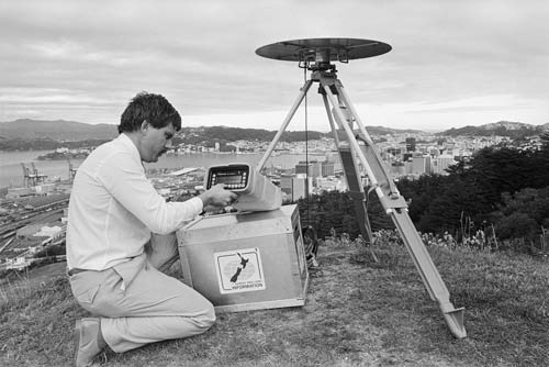
The Global Positioning System (GPS) was invented by the United States military and uses satellite data to accurately locate positions on the earth. Here a Department of Survey and Land Information surveyor inspects the large and cumbersome equipment needed in the 1980s.
Te whakamahi i tēnei tūemi
Alexander Turnbull Library, Dominion Post Collection (PAColl-7327)
Reference:
EP/1989/1762/34A
Photograph by Jon Hargest
Permission of the Alexander Turnbull Library, National Library of New Zealand, Te Puna Mātauranga o Aotearoa, must be obtained before any re-use of this image.

Tāpiritia te tākupu hou