


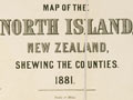
Zoom in to read details of this 1881 map showing the boundaries of the 31 South Island counties. When provincial government was abolished in 1876 these counties were created, based on the boundaries of existing roads boards. In later years the number of counties increased and by 1921 there were 52. Most of the increase took place in Canterbury, where eight counties had become 26.
Using this item
Auckland City Libraries - Tāmaki Pātaka Kōrero, Sir George Grey Special Collections
Reference:
NZ Map 189
Permission of Auckland City Libraries Tāmaki Pātaka Kōrero must be obtained before any re-use of this image.
Add new comment