


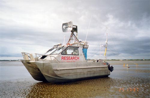
A research vessel sits high and dry on the intertidal mudflats of the Manukau Harbour during low tide. The radar dish on top of the cabin detects the speed of the current in very shallow water. A narrow entrance with a huge basin can exaggerate the tides in enclosed areas such as this – Manukau Harbour has a 4-metre tidal range. Every six hours the harbour changes with the tide from a coastal inlet to a large mudflat crossed with river channels.
Using this item
NIWA – National Institute of Water and Atmospheric Research
Photograph by Craig Stevens
This item has been provided for private study purposes (such as school projects, family and local history research) and any published reproduction (print or electronic) may infringe copyright law. It is the responsibility of the user of any material to obtain clearance from the copyright holder.

Add new comment