


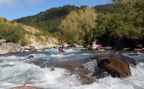
A kayaker runs white water, while two others sit in an eddy awaiting their turn on the lower Mātakitaki River near Murchison. This section of rapids is known as ‘Earthquake’ – it is the part of the river that has cut through the landslide debris that came down in the 1929 Murchison earthquake. The rapids are graded as class III during normal river flows and rise to the more difficult class IV at higher water levels.
Using this item
Private collection
Photograph by Jason Berry
This item has been provided for private study purposes (such as school projects, family and local history research) and any published reproduction (print or electronic) may infringe copyright law. It is the responsibility of the user of any material to obtain clearance from the copyright holder.

Add new comment