

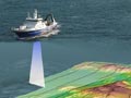
Multibeam mapping collects a wealth of information about the seabed. Layers can be placed on top of one another to give different perspectives. These maps are of the submarine volcano Haungaroa, north-east of New Zealand. The first layer shows water depth, indicated by colour. The second layer also shows depth, depicted by isobaths (underwater contours). The third layer shows topography by shaded relief, which presents more of a three-dimensional view. The fourth layer shows the different types of rock and sediment. The fifth layer depicts sea-floor habitats, plotted using the previous four layers together with information gathered from seabed samples.
Using this item
NIWA – National Institute of Water and Atmospheric Research
This item has been provided for private study purposes (such as school projects, family and local history research) and any published reproduction (print or electronic) may infringe copyright law. It is the responsibility of the user of any material to obtain clearance from the copyright holder.
Add new comment