


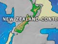
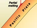
This map shows the tectonically active shores of the Pacific Ocean, where many of the earth’s volcanoes occur. It is known as the Pacific Ring of Fire due to the volcanic activity (and earthquakes) associated with the earth’s plate boundaries. The map also shows the major mid-ocean ridge in the Pacific where rocks form on the sea floor and are slowly moved towards plate boundaries at the ocean edges.
Te whakamahi i tēnei tūemi
Te Ara - The Encyclopedia of New Zealand
This item has been provided for private study purposes (such as school projects, family and local history research) and any published reproduction (print or electronic) may infringe copyright law. It is the responsibility of the user of any material to obtain clearance from the copyright holder.
Source: NIWA – National Institute of Water and Atmospheric Research and NGDC/NOAA - National Geophysical Data Centre, National Oceanic and Atmospheric Administration
Tāpiritia te tākupu hou