


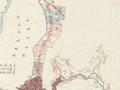
This map shows the street plan of Nelson – which survives largely as planned – and the distribution of the urban sections. The centre of the plan was Trafalgar Square, which never became a market square, but the site of Nelson Cathedral. The colour coding shows land sales and reserves: blue was land that had been sold, yellow were Company reserves, red were colonial (government) reserves and green were native (Māori) reserves – the Native Tenths Reserves. One hundred acres (40 hectares) of Nelson town (one-eleventh, not one-tenth) was set aside in 1842, but much of this was later alienated by the Crown, to the severe detriment of local Māori.
Te whakamahi i tēnei tūemi
Alexander Turnbull Library
Reference:
MapColl 834.1953gbbd/1842/Acc.3045
Permission of the Alexander Turnbull Library, National Library of New Zealand, Te Puna Mātauranga o Aotearoa, must be obtained before any re-use of this image.
Tāpiritia te tākupu hou