


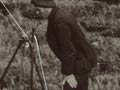
These staff of the New Zealand Aerial Mapping Company are taking aerial photographs of the land around Rotorua. The camera was situated in the nose of the plane, with the lens pointing vertically down. It took photographs automatically, while the plane was flown in straight runs over the land below. Photographs in a run overlapped by around 60%, and the runs themselves had an overlap of about 25%.
Te whakamahi i tēnei tūemi
Archives New Zealand - Te Rua Mahara o te Kāwanatanga
Reference:
New Zealand Mirror, no. 21. National Film Unit, 1953

This item is licensed under a Creative Commons Attribution 3.0 New Zealand Licence

Tāpiritia te tākupu hou