


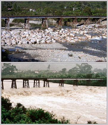
Usually the Waimangaroa River, 17 kilometres north-east of Westport, is a placid stream (top). But after a few hours of heavy rain it becomes a raging torrent (bottom). Such dramatic changes are typical of West Coast rivers when there is heavy rain.
Te whakamahi i tēnei tūemi
Private collection
Photographs by Stuart Henley (top); Simon Nathan (bottom)
This item has been provided for private study purposes (such as school projects, family and local history research) and any published reproduction (print or electronic) may infringe copyright law. It is the responsibility of the user of any material to obtain clearance from the copyright holder.


Tāpiritia te tākupu hou