


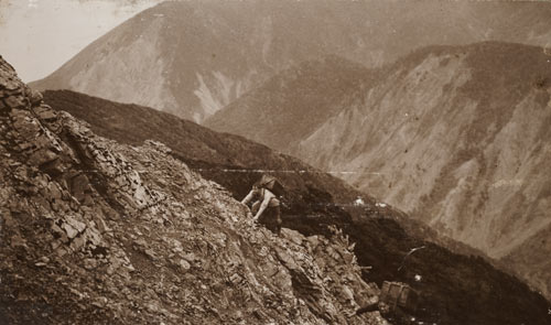
Two members of a survey team carry their equipment up a steep ridge to the Mt Matthews trig station in the Rimutaka Range, around 1913. The large box held by the man on the right weighed more than 36 kilograms. This photograph is from the collection of Hubert Girdlestone, a surveyor with the Department of Lands and Survey and an alpine climber. After his death in the First World War, two peaks were named after him, one on Mt Ruapehu and one in the Tararuas.
Te whakamahi i tēnei tūemi
Alexander Turnbull Library, Hubert Girdlestone Collection
Reference:
PA1-q-913-08-4
Photograph by Hubert Earle Girdlestone
Permission of the Alexander Turnbull Library, National Library of New Zealand, Te Puna Mātauranga o Aotearoa, must be obtained before any re-use of this image.
Tāpiritia te tākupu hou