


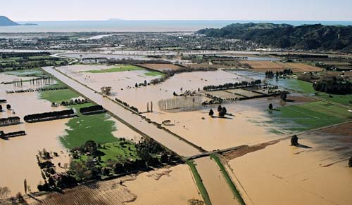
In 2004 the Whakatāne and Rangitāiki rivers in the Bay of Plenty flooded after heavy and prolonged rain, inundating 17,000 hectares of farmland. The Whakatāne River spilled into the central business district of Whakatāne. Because of the extent of farms and settlement on the Rangitāiki Plains, the floods were devastating in their effects.
Te whakamahi i tēnei tūemi
Lazer Photos and Cameras, Whakatāne
Photograph by Bo Thompson
This item has been provided for private study purposes (such as school projects, family and local history research) and any published reproduction (print or electronic) may infringe copyright law. It is the responsibility of the user of any material to obtain clearance from the copyright holder.

Tāpiritia te tākupu hou