


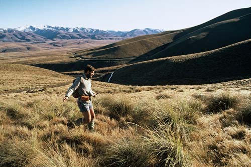
Mike Clare of the Department of Conservation’s Protected Natural Areas unit measures out a fenceline in the Hawkdun Range, Otago. In the early 1990s the Hawkdun ecological district was surveyed as part of the Protected Natural Areas Programme. This initiative mapped all of New Zealand’s ecological districts, made an inventory of landforms, plants and animals, and recommended new protected areas.
Te whakamahi i tēnei tūemi
Department of Conservation
Reference:
10047421
Photograph by Neville Peat
This item has been provided for private study purposes (such as school projects, family and local history research) and any published reproduction (print or electronic) may infringe copyright law. It is the responsibility of the user of any material to obtain clearance from the copyright holder.
Tāpiritia te tākupu hou