


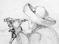
One of the first things Captain John Stokes and the crew of the Acheron did after arriving in Auckland in 1848 was to fix the first trigonometrical station as the starting point for the hydrographic survey of New Zealand. It was set up in Devonport, on what is now the Windsor Reserve, on the waterfront. The plaque gives the latitude as 36°50′5″ south and the longitude as 174°47′45″ east.
Te whakamahi i tēnei tūemi
Te Ara - The Encyclopedia of New Zealand
Photograph by Melanie Lovell-Smith
This item has been provided for private study purposes (such as school projects, family and local history research) and any published reproduction (print or electronic) may infringe copyright law. It is the responsibility of the user of any material to obtain clearance from the copyright holder.

Tāpiritia te tākupu hou