


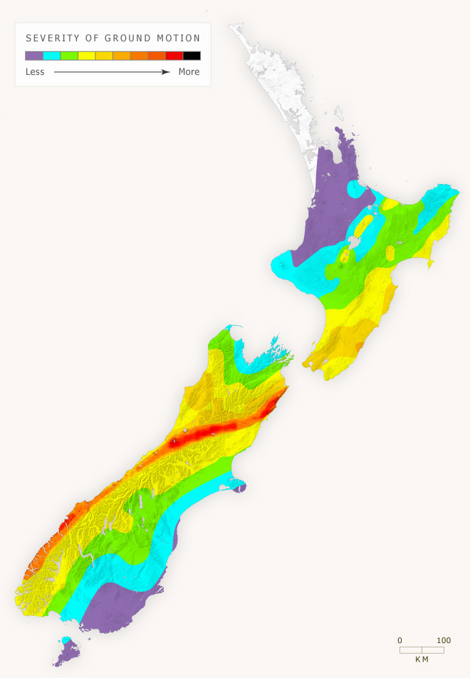
Some parts of New Zealand are more likely to experience severe earthquakes than others. The colours on this map indicate the likely severity of shaking in different areas – in technical terms, the ground motion which has a 10% chance of occurring within 50 years. These predictions are based on the distribution of active faults, how frequently faults have moved in the past, and the location of historic earthquakes. The zone where the strongest shaking is likely corresponds to the southern part of the Alpine Fault, extending along the Hope Fault into Marlborough.
The 2010–11 Canterbury earthquakes are outside the areas of greatest statistical risk of high ground shaking. This illustrates the point that large earthquakes may occur anywhere in the New Zealand region, not just in the highest risk areas.
Te whakamahi i tēnei tūemi
Te Ara – The Encyclopedia of New Zealand
This item has been provided for private study purposes (such as school projects, family and local history research) and any published reproduction (print or electronic) may infringe copyright law. It is the responsibility of the user of any material to obtain clearance from the copyright holder.
Source: GNS Science

Tukunga
These comments seem to be
Sean (not verified)
28 o Tīhema 2013
It's the thought of moving
Marty (not verified)
12 o Ākuhata 2013
yeah i think these geo net
Reuben gray (not verified)
28 o Hune 2011
Thanks for your comment Zoe.
Te Ara (not verified)
08 o Māehe 2011
well they got that wrong
zoe (not verified)
04 o Māehe 2011
Tāpiritia te tākupu hou