


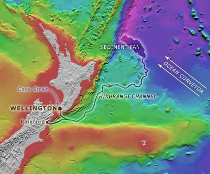
In this bathymetric (sea-depth) map, the Kaikōura Canyon is the tongue of deeper sea floor (coloured green on the map) which abuts the South Island’s east coast at Kaikōura.
Te whakamahi i tēnei tūemi
Te Ara - The Encyclopedia of New Zealand
This item has been provided for private study purposes (such as school projects, family and local history research) and any published reproduction (print or electronic) may infringe copyright law. It is the responsibility of the user of any material to obtain clearance from the copyright holder.
Source: NIWA – National Institute of Water and Atmospheric Research
Tāpiritia te tākupu hou