


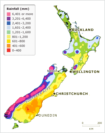
New Zealand’s mountains play a big role in the pattern of the country’s rainfall. Moist airstreams flow in from the Tasman Sea. As they rise over the mountains of the South Island, the moisture condenses and falls as heavy rain on the western slopes. As a result, the country is drier on the eastern side. In the North Island, there is high rainfall on Mt Taranaki, Mt Ruapehu and the Tararua Range. Less rain falls on mountains in the north and east of the North Island, such as the Ruahine, Kaweka and Kaimanawa ranges.
Te whakamahi i tēnei tūemi
NIWA – National Institute of Water and Atmospheric Research
This item has been provided for private study purposes (such as school projects, family and local history research) and any published reproduction (print or electronic) may infringe copyright law. It is the responsibility of the user of any material to obtain clearance from the copyright holder.

Tāpiritia te tākupu hou