


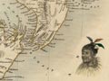
British navigator James Cook made the first map of the entire New Zealand coastline during his visit in 1769–70. Many surviving place names conferred by Cook appear on the map, including East Cape, Cape Campbell and Cape Farewell. It also shows names conferred by Abel Tasman (such as Cape Maria van Diemen) and Māori names (such as Toaipoonamoo for Te Wai Pounamu, the South Island).
Using this item
Alexander Turnbull Library
Reference:
PUBL-0037-25
Permission of the Alexander Turnbull Library, National Library of New Zealand, Te Puna Mātauranga o Aotearoa, must be obtained before any re-use of this image.

Add new comment