


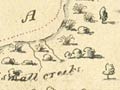
In 1827, after discovering French Pass and sailing through Cook Strait, Dumont d’Urville examined the east coast, from Cape Campbell to Whangārei. During this survey he prepared these two charts, showing Tolaga Bay (top), and Bream Bay with the entrance to Whangārei Harbour.
Using this item
Alexander Turnbull Library
Reference:
MapColl-832.11aj/1827/Acc.32474
Permission of the Alexander Turnbull Library, National Library of New Zealand, Te Puna Mātauranga o Aotearoa, must be obtained before any re-use of this image.
Add new comment