


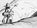
This map for miners, produced early in the gold rush years, shows routes to both Gabriels Gully and the ‘new diggings’ – the 1862 finds at the Dunstan (later Clyde). It depicts an existing route to Gabriels Gully which roughly follows the present State Highway 8, and a shortcut promoted by ‘Red Coat’, the mapmaker (accompanied in his drawing by a reluctant packhorse). The routes to the new diggings were later known as the ‘old Dunstan’ and the ‘Pigroot’. The map is not very accurate, and Red Coat’s shortcut was little-used.
Using this item
Toitū Otago Settlers Museum
Reference:
DC-2652
Permission of Toitū Otago Settlers Museum must be obtained before any re-use of this image.

Add new comment