


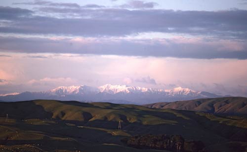
These flat-topped hills (foreground) in Belmont Regional Park are known to geologists as a peneplain or ‘K Surface’ – after Mt Kaukau, a city landmark. They are a feature of the landscape on the western side of the Wellington Fault. In the distance is the sharper outline of the Tararua Range. While the peneplain and the Tararua Range are made of the same greywacke rock, the ranges have been uplifted more rapidly than the hills.
Te whakamahi i tēnei tūemi
Private collection
Photograph by Chris Maclean
This item has been provided for private study purposes (such as school projects, family and local history research) and any published reproduction (print or electronic) may infringe copyright law. It is the responsibility of the user of any material to obtain clearance from the copyright holder.
Tukunga
It is almost 100 years since
Simon Nathan (not verified)
23 o Ākuhata 2010
Hi, the K-surface was named
Martin Brook (not verified)
18 o Ākuhata 2010
Tāpiritia te tākupu hou