


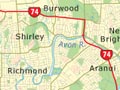
This map shows the area declared unsuitable for building after the 2011 earthquakes. All buildings in the area had to be either removed or demolished. The red zone followed the course of the Avon River because the land along its banks was unstable. The suburbs of Dallington, Burwood, Avondale and Bexley were especially severely affected and lost much of their population.
Using this item
Canterbury Earthquake Recovery Authority
This item has been provided for private study purposes (such as school projects, family and local history research) and any published reproduction (print or electronic) may infringe copyright law. It is the responsibility of the user of any material to obtain clearance from the copyright holder.

Add new comment