


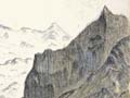
Having worked with the surveyors G. J. Roberts and Gerhard Mueller, Charlie Douglas became an excellent map maker. He spent a winter working on two huge maps of South Westland, from Hokitika to Big Bay – one of them was over 5 metres wide. This section of the southern map centres on the junction of the Clarke and Landsborough rivers where they join the Haast River. At the top are the Paringa and Ōtoko rivers, near the intriguingly named Valley of Darkness. The red markings indicate places which Douglas felt had economic potential. The maps were shown at the 1906–7 Christchurch Exhibition.
Using this item
Archives New Zealand - Te Rua Mahara o te Kāwanatanga

This item is licensed under a Creative Commons Attribution 3.0 New Zealand Licence
Add new comment