


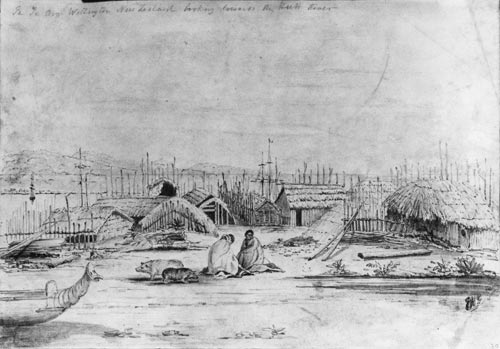
Te Aro pā was established around the 1820s, and covered about 2 hectares in the 1840s, when this drawing was made. It was divided in two, with Ngāti Ruanui people living in the eastern end and Taranaki people at the western end. As Wellington grew, British colonists called for the pā to be sold. The residents resisted, but the settlers forced the issue and by 1870 it had been subdivided and sold. In 2005, archaeologists uncovered the remains of three huts.
Using this item
Alexander Turnbull Library
Reference:
A-049-001
Pencil sketch by Edmund Norman
Permission of the Alexander Turnbull Library, National Library of New Zealand, Te Puna Mātauranga o Aotearoa, must be obtained before any re-use of this image.


Comments
I like this site because it
Chloe (not verified)
16 February 2014
Add new comment