


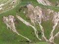
This is a lateral spread landslide at the locality known as Earthquakes, in the Waitaki Valley, North Otago. The scarp (the line on which the ground has failed) is marked by the green line. The slide has moved from left to right, with the toe of the slide pushing out into the river bed, diverting it to the right. A hard cap rock of limestone collapsed and spread to the right as the soft mudstone beneath it was deformed. The hummocky surface reveals the extent of the landslide surface.
Using this item
Private collection
Photograph by Mike Crozier
This item has been provided for private study purposes (such as school projects, family and local history research) and any published reproduction (print or electronic) may infringe copyright law. It is the responsibility of the user of any material to obtain clearance from the copyright holder.

Add new comment