


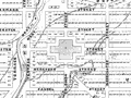
Wellington’s plan was designed by New Zealand Company surveyor William Mein Smith in 1840. It comprised a series of interconnected grids which expanded along the town’s valleys and up the lower slopes of hills.
Using this item
Alexander Turnbull Library
Reference:
MapColl 832.4799/1840/Acc.317
Permission of the Alexander Turnbull Library, National Library of New Zealand, Te Puna Mātauranga o Aotearoa, must be obtained before any re-use of this image.

Add new comment