


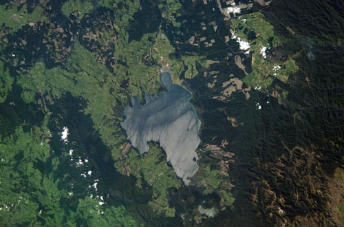
The land faulting that shaped some of Lake Taupō’s shoreline can be seen in this aerial view, particularly on the lake’s south-west side. The different landscapes around the lake are also visible – the once-forested land (now farms) to the north and west; the bush-clad Hauhungaroa Range, further west; the plantation forests east and north-east of the lake; and the rugged Kaimanawa Mountains to the south-east. At the bottom of the photo are Pīhanga mountain and Lake Rotoaira.
Using this item
This item has been provided for private study purposes (such as school projects, family and local history research) and any published reproduction (print or electronic) may infringe copyright law. It is the responsibility of the user of any material to obtain clearance from the copyright holder.

Add new comment